Ladysmith flood risk study
Project facts
- ClientSantam
- LocationLadysmith, KwaZulu-Natal Province, South Africa
- Date2022
- ChallengeFlooding was regularly affecting Ladysmith’s community. Insurers needed insight to help clients.
- SolutionA flood risk study to provide insight into the likelihood of flooding and potential areas impacted.
The challenge: frequent floods prompts insurers’ need for insight
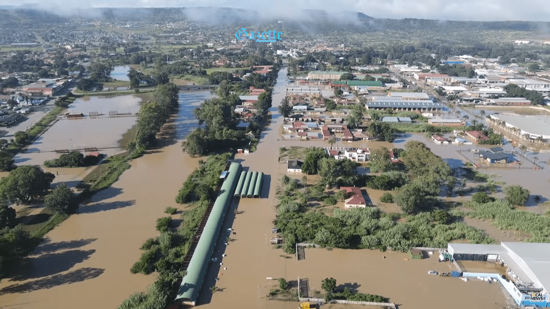
The town of Ladysmith – located in the South African province of KwaZulu-Natal – suffered multiple flood events in its Central Business District (CBD), because of the Klip River. This river flows through the town and overtops its banks regularly during the wet season. In order to prevent these floods from occurring, the Municipality of Ladysmith designed the Ladysmith Flood Protection Scheme (LFPS) which includes a dam, stormwater outlets and levees. Despite the town’s existing flood protection scheme, the floods still have a large impact on the community and prosperity of the town.
Santam was interested to investigate the current flood exposure in Ladysmith during different extreme events as a result of pluvial flooding and river flooding and invited Royal HaskoningDHV to perform a flood study that investigates the sources of flooding and the associated hazards.
The solution: a flood risk study to assess flooding likelihood and impact
The Royal HaskoningDHV team developed a flood model using 3Di software to investigate pluvial and fluvial flood exposure in Ladysmith during different extreme weather events. The model covers 45 km3 and incorporates multiple datasets, including:
- Digital elevation models – including satellite imagery and LiDAR survey data
- Soil types
- Land cover
- Roughness coefficients
It was assumed that stormwater outlets were causing flooding to most of the CBD due to backwater flow from the river to urbanised areas. To test this theory, a detailed survey and a conditional assessment of the existing outlets were undertaken and included in the model. In addition, the team performed a meteorological and hydrological analysis that helped develop scenarios where dam discharges, peak discharges from nearby catchments and local rainfall in the CBD were combined and simulated using the 3Di flood model.

Running this simulation showed the true risk flooding poses to Ladysmith’s CBD. Now the community has the information it needs moving forward.
The result: insights into Ladysmith’s flood risk for informed decision making
The flood study gave Santam a better understanding of Ladysmith’s water system, the sources for flooding and the impact of pluvial flooding on the CBD.
In total, 11 scenarios were simulated and evaluated with the flood model – identifying the most sensitive and flood prone areas under various conditions.
Three different mechanisms were also found to cause inundation of the CBD: local and upstream precipitation, backwater flow from the river into the CBD, and overbank flow due to extreme water levels in the river.
Now, Santam can make better informed decisions to help insure its clients based on new insights in flood-prone areas, flood depths, and the likelihood of different rainfall events.
Want to know moreor got a question?
Contact our Climate Resilience experts!
Our offerings

 Climate resilience